Showing all 6 resultsSorted by popularity
-
Home » Construction Verification
Want to learn more about the LN-160 and how it can help you?
Book a demo with us at a time and place to suit you.
£11,623.00 ex VAT
£13,947.60 inc VATOut of stock
SKU: 1066592-01 Categories: Construction Layout Instruments, Layout & Positioning, Survey, TopconTags: Construction Tool, Construction Verification, Layout Tool, Robotic Station, Setting Out Tool, Topcon, Topcon LN Tool, Topcon Positioning
Description
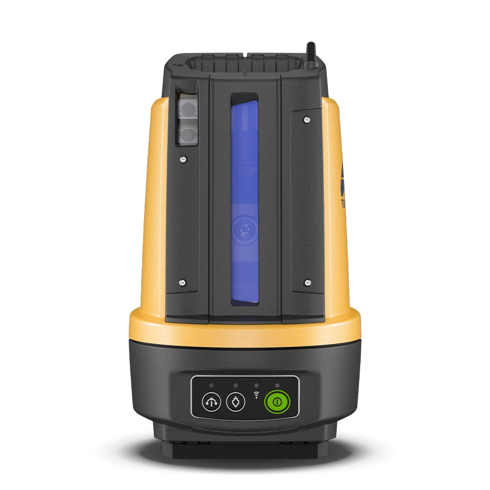
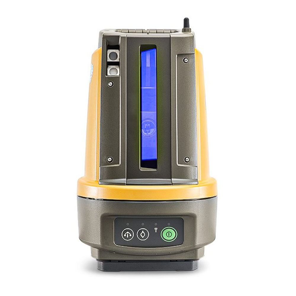
Fast, simple and precise construction layout
The Topcon LN-160 3D Layout Navigator transforms how you approach construction layout, moving you away from tape measures, manual templates and guesswork into fast, accurate digital positioning. Built from Topcon’s robotic total station expertise, the LN-160 gives you intuitive one-person operation and industry-proven precision without unnecessary complexity.
Designed for real construction workflows
Whether you’re laying out foundations, utilities, walls, ceilings or as-builts, the LN-160 delivers reliable results across a wide range of layout tasks. Its smart design takes care of routine setup and keeps you productive from the moment you power on.
Key benefits
Simple one-button setup – self-leveling and ready to go in seconds
Compact, rugged design – built for busy job sites
Accurate 3D layout – position points up to 130 m from the instrument
One-operator productivity – cut layout and checking time dramatically
Seamless digital workflows – pair with tablets or controllers and import design data
Long-lasting power – external battery port for extended use
Why it’s different
The LN-160 isn’t just another total station — it’s a layout navigator engineered specifically for construction teams who need speed and accuracy. From slab layout to cladding checks, it replaces manual methods with precise, reproducible results that you can trust day after day.
Easy to use — even for non-surveyors
With self-leveling and intuitive guidance, the LN-160 is accessible for crews of all experience levels. Pair it with a rugged field tablet or handheld controller, upload your design (CAD/BIM), and the instrument guides you exactly where you need to be — no complex setup required.
Built for modern job sites
Robust construction – waterproof and dustproof for all weather conditions
Wireless connectivity – connect tablets or controllers for real-time layout
Practical range – up to 130 m (426 ft) coverage for most build spaces
Efficient workflows – reduce rework and improve quality control on every project
Typical applications
The LN-160 excels in a range of layout and verification tasks including:
Foundations, footings and utility lines
Walls, slabs and ceilings
Machine control assistance
As-built checks and measurement verification
Complex grids and structural control points
Ready to digitise your layout?
Whether you’re upgrading from manual layout tools or adding a dedicated layout navigator to your fleet, the Topcon LN-160 helps you work faster, smarter and with confidence.
Technical Specifications
Angle Accuracy 5" Distance - prism 130 m Hybrid Positioning Yes Self-levelling single button setup Yes Laser plummet Standard Dust/Water Rating IP65 
Topcon LN-160 Layout Navigator Brochure
Customisable Packages:
Purchase as a standalone instrument, with controller and software or with a MC Mobile installation.
Common kits include LN-160, controller, tripod, pole, Layout software.
*£11,632 package includes LN-160, mini prism and pole set, 12m Layout License and wooden tripod.
Please get in touch for other package options and quantity discounts.
You may also like…
ALSO FROM JB SURVEY
SURVEY EQUIPMENT HIRE
Ad-Hoc hires for survey, safety and machine control
JB SERVICEPLUS
12 Month Service Plan Subscriptions
JB SURVEYPLAN
Hire Subscriptions from JB Survey Limited
-
Home » Construction Verification
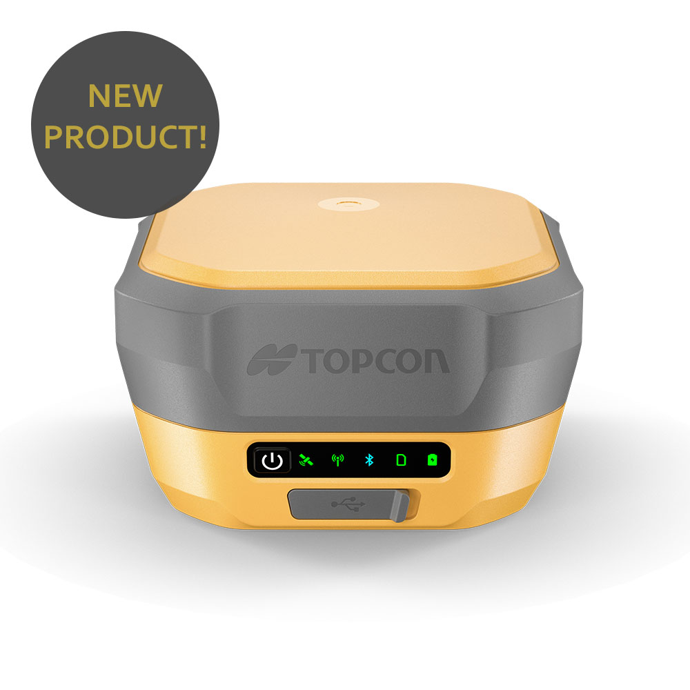
Precision you can trust
£13,522.00 ex VAT
£16,226.40 inc VATOut of stock
Description
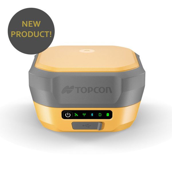
Precision you can always trust
The Topcon HiPer XR is a compact, high-performance GNSS receiver designed for surveying and construction professionals who need reliable RTK results in challenging environments.
With advanced TILT technology, multi-constellation tracking and built-in interference mitigation, the HiPer XR delivers accurate measurements even where signal conditions, obstructions or magnetic interference would normally slow you down.
Accurate measurements — even when the pole isn’t level
At the heart of the HiPer XR is Topcon Integrated Levelling Technology (TILT), allowing accurate pole-tip measurements with the pole tilted up to 60° — without calibration and without sensitivity to magnetic interference.
This means:
Faster point collection
Less time levelling the pole
Safer measurements near obstacles, fences and traffic
Perfect for boundary work, as-builts, utilities and tight construction sites
Built to perform in tough conditions
The HiPer XR is engineered for reliability on real job sites:
Advanced anti-jamming and anti-spoofing technology
GNSS interference monitoring and mitigation
Improved RTK performance for stable, repeatable results
Rugged, shock-resistant design
Lightweight build (under 1 kg) for all-day use
Whether you’re working near buildings, machinery or active sites, the HiPer XR maintains dependable positioning performance
Efficient, modern design
Designed to minimise downtime and simplify workflows, the HiPer XR includes:
Multi-constellation GNSS tracking for improved accuracy
USB-C charging and connectivity
Fast charging — up to 50% in around 30 minutes
Integrated web user interface for easy setup and monitoring
Flexible communication options (models with or without internal radio)
These features combine to deliver a receiver that’s easy to deploy, manage and maintain across multiple projects
Key features at a glance
Calibration-free TILT compensation up to 60°
Immune to magnetic interference
Anti-jamming and anti-spoofing protection
Multi-constellation GNSS support
Lightweight, rugged housing
USB-C charging and data connection
Integrated status display and web UI
Typical applications
The Topcon HiPer XR is ideal for:
Topographic and control surveys
Construction layout and as-built surveys
Utilities and infrastructure work
Boundary and site verification
GNSS rover and base station setups
Why choose the HiPer XR?
If you need a modern GNSS receiver that combines tilt compensation, interference resistance and portability at an accessible price point, the HiPer XR delivers outstanding performance without unnecessary complexity.
Available from JB Survey, with full support, configuration advice and aftersales service.
This item is available to hire from JB Survey Limited
Short and long term hires - Competitive rates - Fast delivery
Technical Specifications
Signals Tracked GPS, GLONASS, Galileo, BeiDou, IRNSS, SBAS, QZSS Precision Static H: 3mm ± 0.1 ppm V: 3.5mm ± 0.4 ppm Static/ Fast Static H: 3mm ± 0.5 ppm V: 5mm ± 0.8 ppm RTK H: 5mm ± 0.5 ppm V: 10mm ± 0.8 ppm Communications Optional Internal Radio, Cellular, Longlink Bluetooth, Bluetooth, USB C Operating Time Up to 15 hours 
Topcon HiPer XR GNSS Receiver Brochure
Topcon HiPer XR GNSS Receiver Data Sheet
Customisable Packages:
Order your new Topcon HiPer XR package today.
Get in touch for options including base and rover and RTK receiver kits.
Delivery usually within 5 working days.
*£13,522 is indicative price for a basic package. Please contact us for full pricing details.
You may also like…
ALSO FROM JB SURVEY
SURVEY EQUIPMENT HIRE
Ad-Hoc hires for survey, safety and machine control
JB SERVICEPLUS
12 Month Service Plan Subscriptions
JB SURVEYPLAN
Hire Subscriptions from JB Survey Limited
-
Home » Construction Verification
Packages start from £7600 ex VAT
£7,980.00 ex VAT
£9,576.00 inc VATOut of stock
SKU: 1070021 Categories: GNSS Receivers, GPS Equipment, Survey, TopconTags: Building Survey, Construction Tools, Construction Verification, CR GPS, GPS Rover, New Topcon GPS, Survey GPS, Tilt GPS, Topcon, Topcon CR, Topcon GNSS, Topcon GPS, Topcon Positioning, Topcon Survey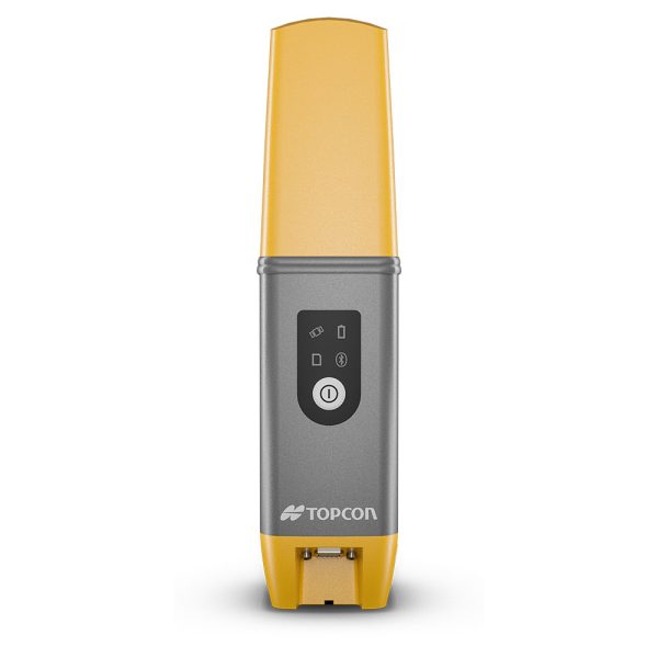
Description
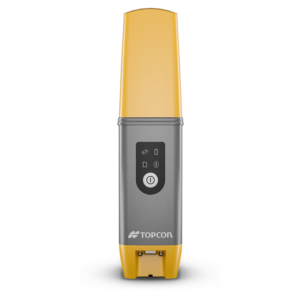
Get precise centimetre-level accuracy effortlessly with this compact powerhouse, ideal for various survey and construction tasks. The HiPer CR is an ultra-lightweight and compact solution that minimizes pole weight, ensuring easy mobility and field usability. Despite its small size, the HiPer CR excels in challenging canopy and jobsite environments, delivering exceptional performance.
This item is available to hire from JB Survey Limited
Short and long term hires - Competitive rates - Fast delivery
Technical Specifications
Signals Tracked GPS, GLONASS, Galileo, BeiDou, SBAS, QZSS Precision Static H: 3mm ± 0.1 ppm V: 3.5mm ± 0.4 ppm Static/ Fast Static H: 3mm ± 0.4 ppm V: 5mm ± 0.6 ppm RTK H: 10mm ± 0.8 ppm V: 15mm ± 1.0 ppm Communications Longlink Bluetooth, Bluetooth, USB 2.0 Operating Time Up to 10 hours 
Topcon HiPer CR GNSS Receiver Brochure
Topcon HiPer CR GNSS Receiver Data Sheet
Customisable Packages:
Purchase as a hybrid upgrade, or stand alone rover set.
Common kits include receiver, controller, pole, Field software.
RTK corrections license available.
*£7,600 package includes CR receiver, Android FC6000, 12m Android Field License and composite rover pole.
Please get in touch for other package options and quantity discounts.
You may also like…
ALSO FROM JB SURVEY
SURVEY EQUIPMENT HIRE
Ad-Hoc hires for survey, safety and machine control
JB SERVICEPLUS
12 Month Service Plan Subscriptions
JB SURVEYPLAN
Hire Subscriptions from JB Survey Limited
-
Home » Construction Verification
£0.00 ex VAT
£0.00 inc VAT
Description
ALSO FROM JB SURVEY
SURVEY EQUIPMENT HIRE
Ad-Hoc hires for survey, safety and machine control
JB SERVICEPLUS
12 Month Service Plan Subscriptions
JB SURVEYPLAN
Hire Subscriptions from JB Survey Limited
-
Home » Construction Verification
Packages start from £12,400 ex VAT
£13,020.00 ex VAT
£15,624.00 inc VATOut of stock
SKU: 1028517-02 Categories: GNSS Receivers, GPS Equipment, Survey, TopconTags: Building Survey, Construction Tools, Construction Verification, GPS Rover, New Topcon GPS, Survey GPS, Tilt GPS, Topcon, Topcon GNSS, Topcon GPS, Topcon Positioning, Topcon Survey, Topcon VR, VR GPS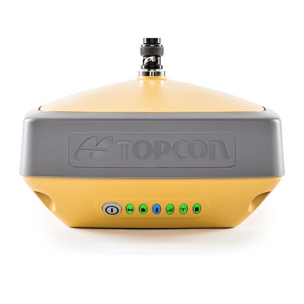
Description
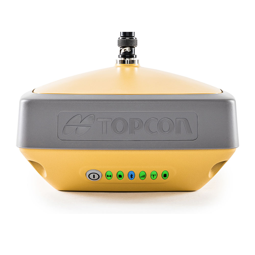
The Topcon HiPer VR is versatile and rugged, designed with the advanced GNSS technology delivering precise measurements in the most challenging of environments. Topcon patented Universal Tracking Channels™️ technology provides the industry’s most efficient approach in identifying and using every satellite signal. All constellation signals are tracked automatically from any available channel. Thus, reaching maximum performance with a reduced number of channels.
This item is available to hire from JB Survey Limited
Short and long term hires - Competitive rates - Fast delivery
Technical Specifications
Signals Tracked GPS, GLONASS, Galileo, BeiDou, SBAS, QZSS, IRNSS Precision Static H: 3mm ± 0.1 ppm V: 3.5mm ± 0.4 ppm Static/ Fast Static H: 3mm ± 0.4 ppm V: 5mm ± 0.6 ppm RTK H: 5mm ± 0.5 ppm V: 10mm ± 0.8 ppm Communications Longlink Bluetooth, Bluetooth, USB 2.0, UHF Radio Operating Time Up to 10 hours 
Topcon HiPer VR GNSS Receiver Brochure
Topcon HiPer VR GNSS Receiver Data Sheet
Customisable Packages:
Purchase as a base station, base and rover set, hybrid upgrade, or stand alone rover set.
Common kits include receiver, controller, pole, Field software.
RTK corrections license available.
*£12,400 package includes VR base receiver, Android tablet, 12m Android Field License and tripod.
Please get in touch for other package options and quantity discounts.
You may also like…
ALSO FROM JB SURVEY
SURVEY EQUIPMENT HIRE
Ad-Hoc hires for survey, safety and machine control
JB SERVICEPLUS
12 Month Service Plan Subscriptions
JB SURVEYPLAN
Hire Subscriptions from JB Survey Limited
-
Home » Construction Verification
This model has been superseded by the Topcon LN-160, offering improved performance and the latest Topcon technology.
View the LN-160
£0.00 ex VAT
£0.00 inc VATSKU: 103500-12 Categories: Construction Layout Instruments, Survey, TopconTags: Construction Tool, Construction Verification, Layout Tool, LN150 Layout Navigator, Robotic Station, Setting Out Tool, Topcon, Topcon LN Tool, Topcon LN150, Topcon Positioning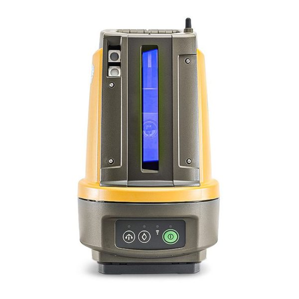
Description
The LN-150 is a compact, self-levelling, easy-to-setup 3D layout tool designed for construction applications.
Use the LN-150 in place of traditional methods such as tapes or other layout tools. Compact, rugged and lightweight, the LN-150 is ideal for construction layout and as-builts.
Rugged compact design. Small and lightweight. Waterproof – dustproof design. Easy to carry Completely sealed housing.
With the press of just one button, the LN-150 automatically self-levels and is ready for action. Pair it with a hand-held, touchschreen controller and you are ready to go to work.
Technical Specifications
Angle Accuracy 5" Distance - prism 130 m Hybrid Positioning Yes Self-levelling single button setup Yes Laser plummet Standard Dust/Water Rating IP65 
Topcon LN-150 Layout Navigator Brochure
Customisable Packages:
Purchase as a hybrid upgrade, or stand alone set.
Common kits include LN-150, controller, tripod, pole, Field software.
*£16,000 package includes LN-150, Android Tablet, 12m Construct License and tripod.
Please get in touch for other package options and quantity discounts.
You may also like…
ALSO FROM JB SURVEY
SURVEY EQUIPMENT HIRE
Ad-Hoc hires for survey, safety and machine control
JB SERVICEPLUS
12 Month Service Plan Subscriptions
JB SURVEYPLAN
Hire Subscriptions from JB Survey Limited